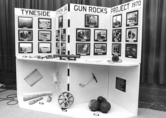
Today it was snowing, the wet snow that no one likes, so I took the day to sort out some of the photographs for Gun Rocks. This has resulted in me installing a new widget for photo albums to the website and learning how to use it. Followed by uploading about 100 photographs on to the Gallery Page. There are plenty more to upload, but for now, they give a good flavour of what the project has been about over the last year, and how Tyneside 114 (BSAC) has been involved. Two of the albums are dedicated to the original team from the 1970s.
If anyone else has any photographs that they would like me to add, then do contact me through the contact form, or directly if you have my email address, and we can put them up in an album.
Next task is setting up the templates for the leaflets, so that we can have them ready for the setting of the dive trail in the spring (as soon as the weather allows us). If anyone can make leaflets, or has experience of publisher, then do let me know.
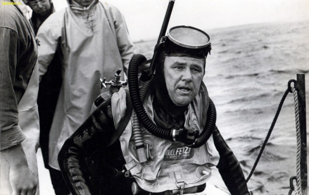
Bill Smith was the Branch Diving Officer of Tyneside 114 back in the late 1960s, and was the inspiration for the club’s subsequent involvement with Gun Rocks. He lead the first project to investigate and map the cannon in 1970, was the author of the first report on the site, and was immensely proud of being the ‘Salvor in Possession’ of the Gun Rocks wreck.
Sadly, Bill died in 2016. On a sunny July afternoon, and with Bill’s family watching, members of Tyneside 114 were honoured to take Bill on his final dive and scatter his ashes amongst his beloved cannon.
For more information about Bill, the inspiration behind Gun Rocks and a short video showing divers releasing his ashes on to Gun Rocks, please visit the Tyneside 114 website.
Finally after much emailing and telephone conversations, the Marine Management Organisation have granted Gun Rocks a licence to put in the trail and marker buoy.
The initial application was submitted on 14th May 2017, after which I was advised that this application could not be evaluated under the fast track scheme and that it would have to go the general route and the cost would be £450 for the licence.
As part of the MMO licence we had to put up a message of intent to create a dive trail.
The MMO then told me that the process would take a maximum of 13 weeks, but as my application was so simple they thought that it would be much more rapid than that. Okay I thought, 13 weeks that’s three months and will take me to the middle of August, at the latest. We should then be able to install the trail in time for the final few weeks of the dive season.
The licence was granted on the 14th September 2017. So took a total of 18 weeks to be processed. Unfortunately the timing has meant that we have now decided to delay putting in the trail until the end of March, start of April 2018. The intention is that by this time, the winter storms will have passed and the leaflets and trail mapping will all be printed and available.
Maybe we should organise a grand opening in 2018? 🙂 In the mean time there are still lots of activities to do in the name of Gun Rocks, one task is for me to finish building this website…..
Part of the Gun Rocks funding was earmarked to increase the knowledge of archaeological survey techniques for club members. Although some members already had some Nautical Archaeological Society training, many didn’t and we chose the BSAC Wreck Appreciation course as a good starting point. While this course focusses on wrecks where there is a recognisable vessel and not just cannon, the basic techniques for mapping and recording the artefacts are the same.
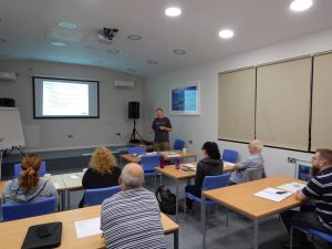
Classroom based skills, day 1 of the Wreck Appreciation Course.
The course consists of a day of theory and dry practical lessons, followed by a day of diving and putting the techniques into practise on a suitable wreck. We spent Saturday 19th August hidden away in the lecture room of the Diving Centre in Boldon; learning all about how to locate wrecks, what we should expect to find and how parts of the wreck should fit together, what law governs activity on wrecks, and how to conduct a practical survey. After many hours discussing kit configurations, and practising how to use tape measures and distance lines in silence, we felt prepared enough to venture into the water the next day.
Too much to handle!
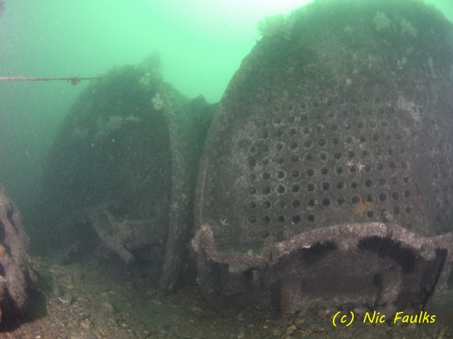
Sunday 20th turned out to be a good day for diving: a slight breeze and a bit of sun. Boarding Spellbinder, we set off out of the Tyne, heading for our target wreck: the Lonclara. PLA Hopper No 20 was a Port of London Authority hopper barge, which was converted to a cargo steamer and renamed the Lonclara in 1916. On 4th January 1917 it hit a mine laid by UC-31 and sank off Hendon Rock (Sunderland) with the loss of 4 lives. It now lies in 2 parts in a minimum depth of 15 metres; and we chose to dive the stern section, where the boilers, engine block, propeller shaft, propeller and rudder are all still easily recognisable.
The 2 survey teams jumped in, and spent dive 1 working out how the wreck was lying, where each part was in relation to the next, sketching the sit, and considering how best to accurately map and measure a section of the site. After a surface interval spent drawing plans for the measuring phase, and working out how best to carry the collection of tapes, lines, slates and weights; the 2 teams were ready for the real work.
Happy ladies on the practical skills day of the Wreck appreciation course.
A little after slack, there was a greater depth and a bit more current this time, but there followed 45 minutes of frantic line laying, measuring and recording; with each team taking a different part of the wreck. Back on board Spellbinder, the usual Spellbinder lunch of chicken curry and rice disappeared quickly as we headed back to the Tyne and the 2 teams each compiled their plans; which conveniently overlapped. Success! With some adjustment to the scale, the 2 plans matched up where they were meant to, and we had the start of an accurate plan of the site; it takes more than 2 dives to map a whole site, but we had shown the techniques worked and would have produced a plan of the entire site over a series of dives.
Whilst we won’t be mapping a ‘normal’ wreck on Gun Rocks, the techniques learned will be ideal to assist in accurately mapping the locations of all the cannon on the site.
On July 30th 2017, we took the club rhib out for what we hopped would be a concerted weekend of diving on Gun Rocks to clear some of the cannon of seaweed, to photograph them and to work out how much rope we needed for the trail. Unfortunately the weather gods weren’t so obliging with us, nor was the moon god with her tide timings.
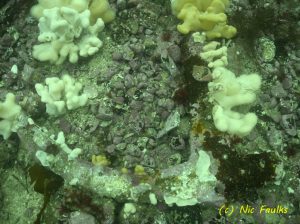
We did manage to get two dives on Gun Rocks on the Saturday, clearing a couple of cannon and looking at the best way to get the trail laid. This was Paul’s first dive on Gun Rocks, so he was given a full guided tour of all of the cannon, including the new find from last month by Simon. It was all a bit swelly so it made taking photographs very difficult and the visibility wasn’t great.
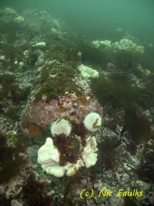
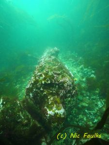
Admiralty Pattern Anchor covered with life and one side broken.
On the Sunday, Si and his buddy did their first dive on the Gun Rocks cannon, clearing the way for the trail to be laid as soon as the MMO licence is granted and checking that the marker buoy was safely attached. (Something we can put in for 28 days without a licence).
After their dive, Nic and Paul caught slack in the sound. This dive is always a challenge, partly because you never quite know how long slack will last and secondly because the sea bed in the sound is quite featureless, making navigation quite difficult. We located seven cannon in the sound, all remarkably deteriorated, on the flat sea bed. We then found an Admiralty pattern anchor, which appeared to have had one side snapped off. Took lots of photographs of this.
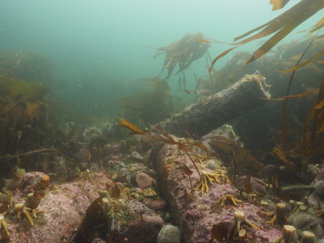
A new cannon found close to the slope up to Gun Rocks.
Then…. then…. on the way back towards the shallows of Gun Rocks we found an 7th cannon lying in the sound!! It is positioned at the bottom of the slope, just below the main cannon site. Due to the swell and wind I couldn’t mark it, but took photos and tried to fix in my mind where it is, so I can find it next time.
With Si’s find last month (the 14th cannon on the Gun Rocks site) and this find, that takes to number of cannon across the two sites (Gun Rocks and Staple Sound) to 14 +7 = 21 recorded cannon. The new finds also link the two sites more closely – there now is probably not more than 20 metres between the canon originally found in the sound and those on the shallow Gun Rocks.
It just seems that every time we dive this site we find something else. One day maybe we will solve the mystery of the ship which sank with such a range of cannon on board.
The club rhib is in being serviced. In the mean time, the Gun Rocks Project has been moving forward, but in paperwork form.
After hearing nothing from the MMO since submitting some additional information on the 26th May, I gave them a call. They had originally told me that the application could take up to 13 weeks. So after calling them on July 10th, I found out that they had just not processed the application at all. It had gone into the data highway equivalent of oblivion. So needless to say I wasn’t too impressed. They then started the application process and informed me that to even consider the application further ( i.e. the placing of four bits of string one for the marker buoy and 3 for the dive trail) it would cost the project £450. The time to process…. currently not determined. But the big issue is apparently the work will be undertaken in an Site of Special Scientific Interest (SSSI). The SSSI designation only goes down to the low tide line, the marker buoy will float in top of the water, so needs to be considered – will it have a likely significant effect on the designating features of the SSSI? Anyway, we wait in hope of getting a licence this dive season. Fingers crossed.
I have also been in touch with the North East Film Archive with regards to the footage from the 1970s. It isn’t the original TV broad cast, but the out takes and other bits which weren’t used. Never the less, we consider that it will be useful and quite interesting to watch. We are going to get all of the footage digitized, then chose the best 5 or 10 minutes to add to the website. There may also be some underwater footage which could throw up some new cues as to where interesting things may be. Apparently there is footage of some sward hilts covered in concretion. Watch this spot!
So the calendars are out, and we hope to get a few weekends of diving in as soon as we can. It would be great to get the trail in and the maps complete by the end of August. If possible it would also be good to get some footage of the dive trail (as it is now) uploaded too. We now have a MUVI waterproof camera to film it on. The photogrammetry is continuing, and as always we hope to upload the competed efforts for your perusal. Rest assured, things are happening. 🙂
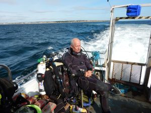
Three whole days of diving organised for the late May bank holiday; with at least one dive a day on Gun Rocks. Time to get the new marker buoy in and to remap the cannon and if time permits, to start the photogrammetry of the cannon left to do….
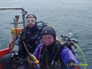
Greg and Nic in the sun
Saturday 27th dawned so bright and sunny. With five on the boat, we set off early, as this was a weekend of springy springs. First dive was on the Crumstone, which was scenic and relaxing. The second dives were on Gun Rocks. Cleaning off cannon 6001 ready to photograph, and remapping the cannon. Unfortunately Nic didn’t manage to map much and ended up directionally confused; however she was ecstatically happy to find an octopus’ layer, with resident, adjacent to cannon 6001. Si completed his mission, to anchor the new buoy to mark the start of the dive trail and show Richard where all of the cannon are.
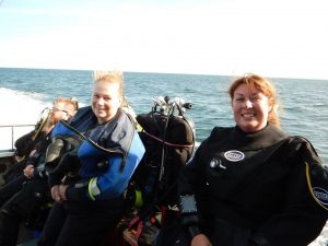
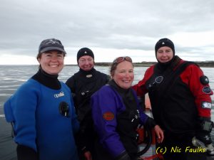
Ladies day on the rhib
Sunday 28th wasn’t so sunny, but was a day of frenetic activity! The first dive was on the north side of inner sound, for Becky, Nic and Lindsay. Lots of critters to photograph. We then headed over to Gun Rocks, where Si and Peta managed to measure and take bearings of all thirteen of the cannon. This was done so that we could realign and check the mapping provided by Wessex, as we always felt that it just wasn’t quite right. Nic, Becky and Lindsay then went down and Becky took wildlife photos for this website, Lindsay took some film footage and Nic cleaned up cannon number 6001 for photographing on Monday.
Si and Peta remap the cannon
By the evening, Si and Peta had drawn up a new improved map of the Gun Rocks cannon, finally we have something that we are happy to put into production!
Monday 29th started a bit cloudy, but the sea was flat calm. We headed straight out to Gun Rocks to dive the Staple Island side. Si dived for a full 45 minutes in 4-6 metres of water looking for the mythical cannon which lies on this side of the rocks, but unfortunately after battling with kelp never managed to find it…. though he did find one later! Nic and Peta then went down on to the main site, Nic took 200+ photos of cannon 6001 for photogrammetry and Peta continued to measure and record all of the cannon. Success, all done…. then as we headed to the surface Peta lost the dive slate with the measurements on… oh no!
Cannon cleaned ready for photogrammetry
Si then jumped in with his scuba kit on. He didn’t find the dive slate, but what he did find was the 14th cannon! It lies on the edge of the Gun Rocks plateau, just above the drop into Staple Sound. It has a very clean round trunnion; you almost feel like it should display a clear ‘F’ or some other symbol. Si took some photos of his find.
Discussions now centre upon whether we should be including this new cannon in the dive trail, as it may lead people out and in to the sound, which can only be dived on slack….. The location of this cannon, does however increase the likelihood that the cannon on the Gun Rocks plateau are more likely to be from the same wreck as those in Staple Sound. The finding of cannon 14 means that the two groups of cannon are now only separated by approximately 15-20 metres.
The funding is now in place but then there are the licences. Yes, we need a Marine Management Organisation (MMO) licence to “deposit” rope in the sea bed. So I have been in consultation with some nice people at the MMO, one is even a diver himself, who have advised me which licence to go for…. Its called a “Fast Track Licence” which takes 13 weeks to process. Ironically the normal licence also takes 13 weeks, but there is a price difference. The Fast Track only costs marginally more than the cost of putting the trail in, the normal one, costs a lot more. So fingers crossed that it is a smooth process.
We are hoping to be out on Gun Rocks over the Bank Holiday weekend, this is to put the navigation or start marker buoy in (we can do this under the 28 day temporary buoy rule, no MMO licence required). We will also be more accurately locating the cannon for the map using measuring tapes and a compass.
If any one would like to help then please let me know.
We now have the official go ahead letter from the Heritage Lottery Fund. Although we knew we had secured funding back at the end of March, we were not given the official nod, allowing us to start work until near the end of April. So far, three days of diving has been undertaken on Gun Rocks. (Two further days lost to the weather). The trail has been cleared of kelp and the cannon located – all 13 of them. However the Wessex Archaeology derived map isn’t looking as accurate as we first thought, so we are hoping to remedy this on the late May Bank Holiday Weekend.
The discussion now is whether we put a rope on the trail, or just buoy a few of the cannon and hope that divers can use a map to navigate around to each of the cannon. The rope would make it easy, but the map and buoy approach would be more fun… I guess the best way to find out which works best is to have some divers come and visit to try out the trail (both with and without a rope) and let us know what they think.
I am also currently trying to track down someone at the Marine Management Organisation in Newcastle to talk to to clarify whether we need a licence to buoy the start of the trail, and to put in a rope trail (if we do). All licences cost money and take time. If Gun Rocks was a protected wreck, then we wouldn’t need an MMO licence. At least we can temporarily mark the start of the trail (28 days) without the need for a licence, so the process shouldn’t hold us up, or the project suffer.
In other news, Joe Mallon has been doing a lot of research for this project. Hopefully I can meet up with him this month to see what we can put on the website for all to see. It sounds as if he has made some quite exciting finds, some which may shed light on the origins of the wreck(s) which deposited the cannon.
So it is all go at the moment. Sometimes I feel that there are not enough hours in the day!
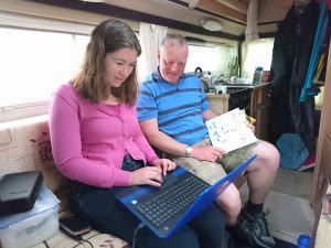
After a full day at work, I have decided that radio 4 and a glass of wine is definitely the way forward for creating the right atmosphere to complete what I hope to be a functional website. There is much to do, learn and upload. I just hope that i am up to the task!
I have to say that Linkedin Learning tutorials have been invaluable for learning how to work with a website, so too has WordPress for Dummies! So stay with me, and watch this website evolve. 🙂